SHOT ROCK (Au-Ag) Nova Scotia
Introduction
In 2018 Northern Shield confirmed the discovery of a low sulphidation epithermal system in outcrop at the Shot Rock Property. This is the first time that this style of gold mineralization has been identified in Nova Scotia. The maiden drill program on the property, completed in March 20200, includes grades up to 22.1 g/t Au over 0.4 m. The mineralization is found within quartz veining exhibiting textures and mineralogy consistent with those from known epithermal systems. Textures observed include crustiform banding, colloform banding and bladed calcite pseudomorphed by quartz, comb texture and other void fillings.
Low sulphidation deposits are highly prized for their potential to host “bonanza” grades of gold and silver.
Location
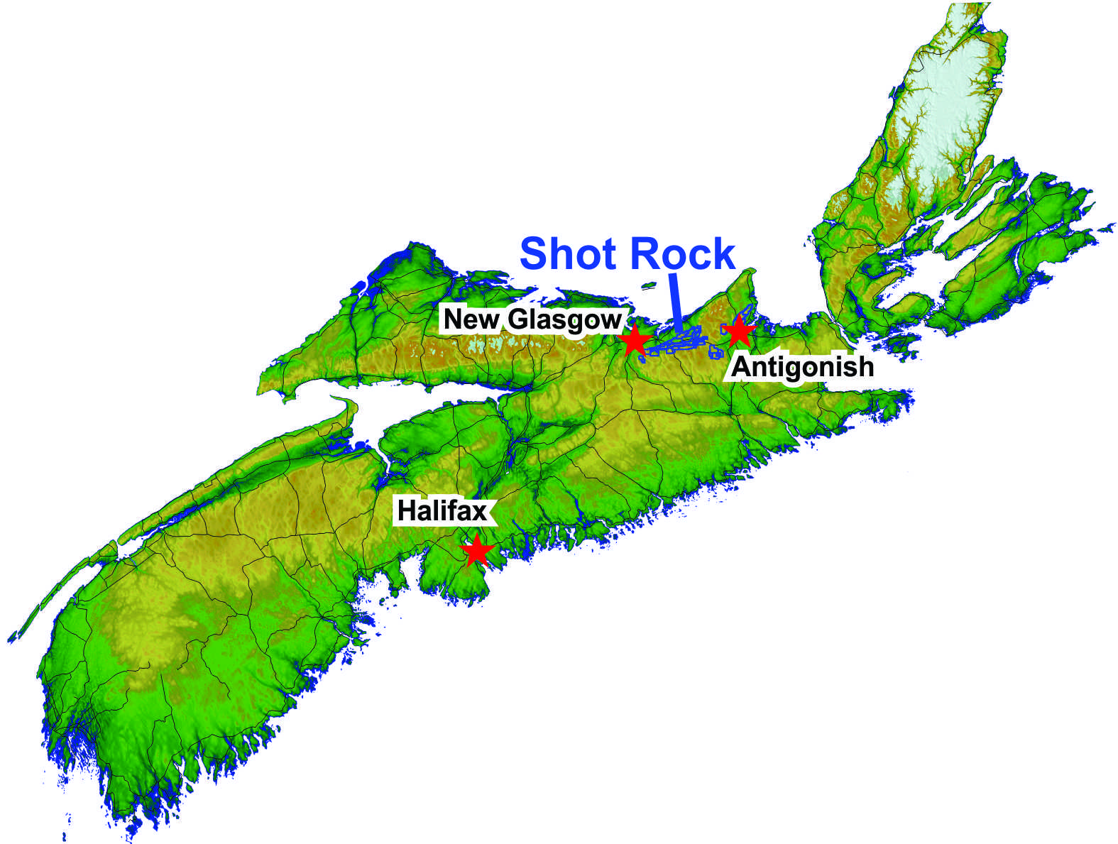
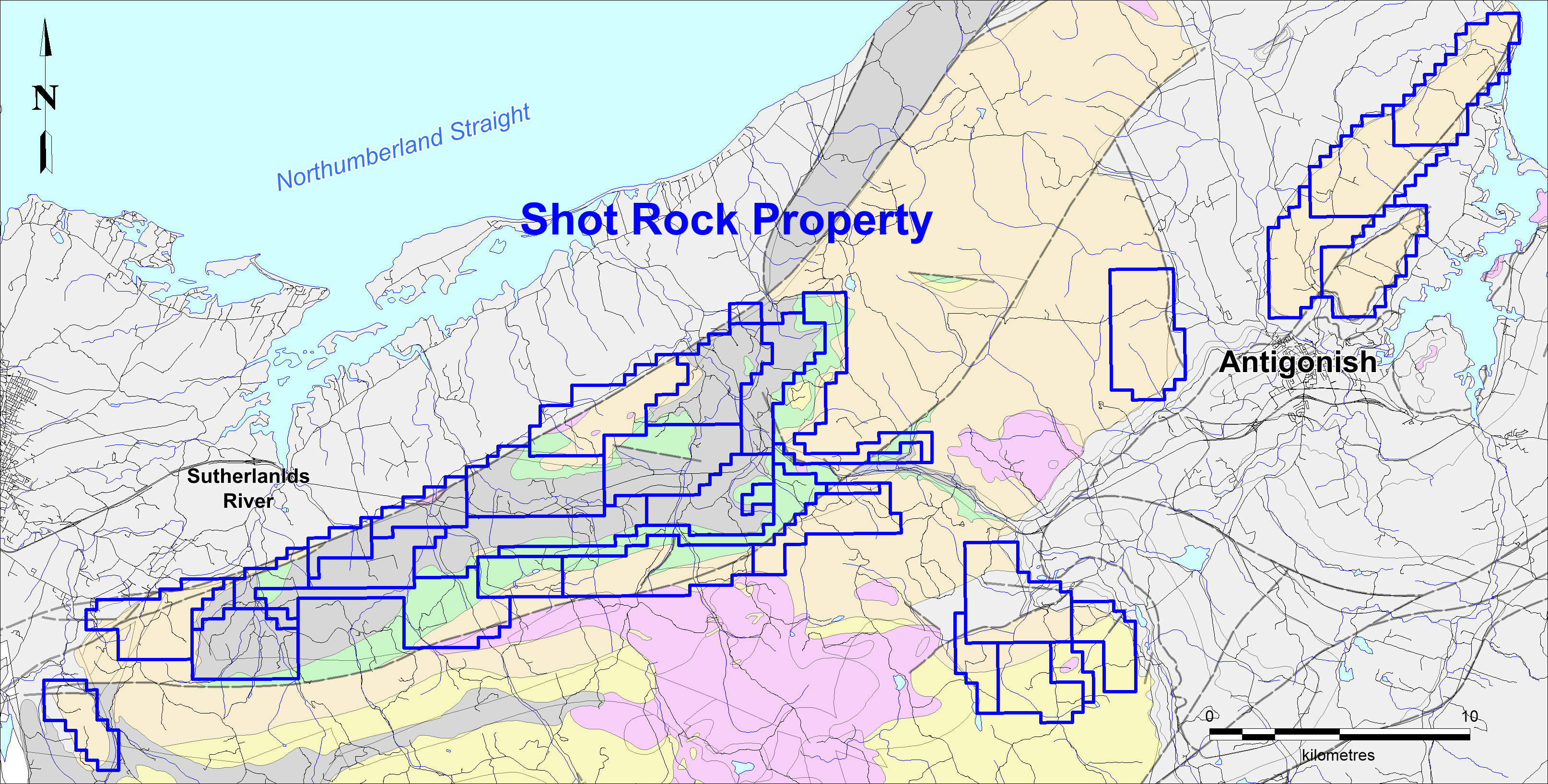
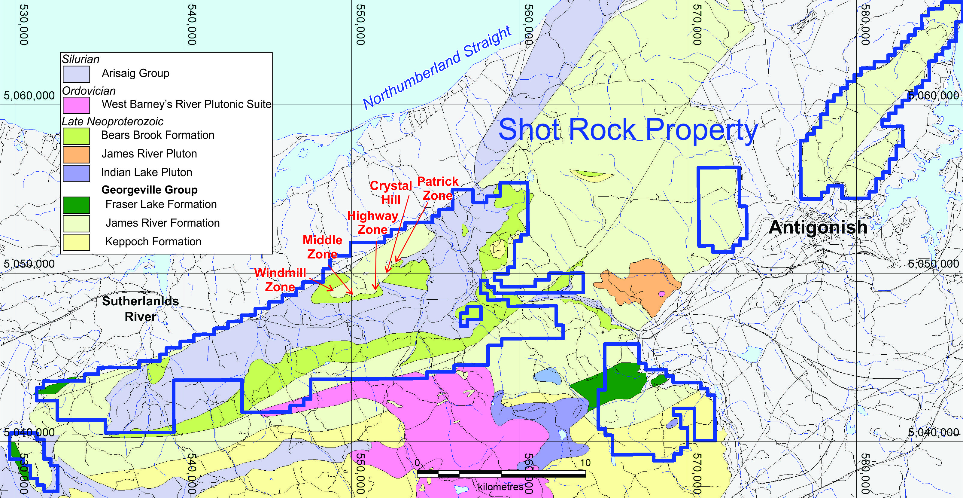
The Shot Rock Property is currently composed of 35 mining licenses units staked under the terms of the Mineral Resources Act of Nova Scotia and represents a total area of around 300 square km. It is located along the Trans-Canada Highway between New Glasgow and Antigonish in Nova Scotia. A railway and power lines also cross the property.
Property Ownership
In 2017, Northern Shield, through wholly-owned subsidiary Seabourne Resources, signed an option agreement with prospector, Patrick Bellefontaine that gives the Company the right to acquire up to an 80% interest in the Shot Rock Gold Property. Seabourne has currently met the conditions of this Option Agreement for a 50% ownership in the Shot Rock Property. The additional 30% can be earned by incurring a further $1.5 million of exploration expenditures within 2 years and make cash and share payments to the prospector over the same period.
The prospector will retain a 1% NSR of which half (0.5%) can be bought back by Northern Shield for $1M.
Summary
Exploration commenced at Shot Rock in June 2018. The initial phases focused on stream sediment sampling while at the same time getting a better understanding of the geology of the area. The stream sediment sampling results:
- confirmed the presence of anomalous gold in the streams in the Barney’s River South area, where historic sampling in the 1970s had identified highly anomalous gold in heavy mineral concentrate samples;
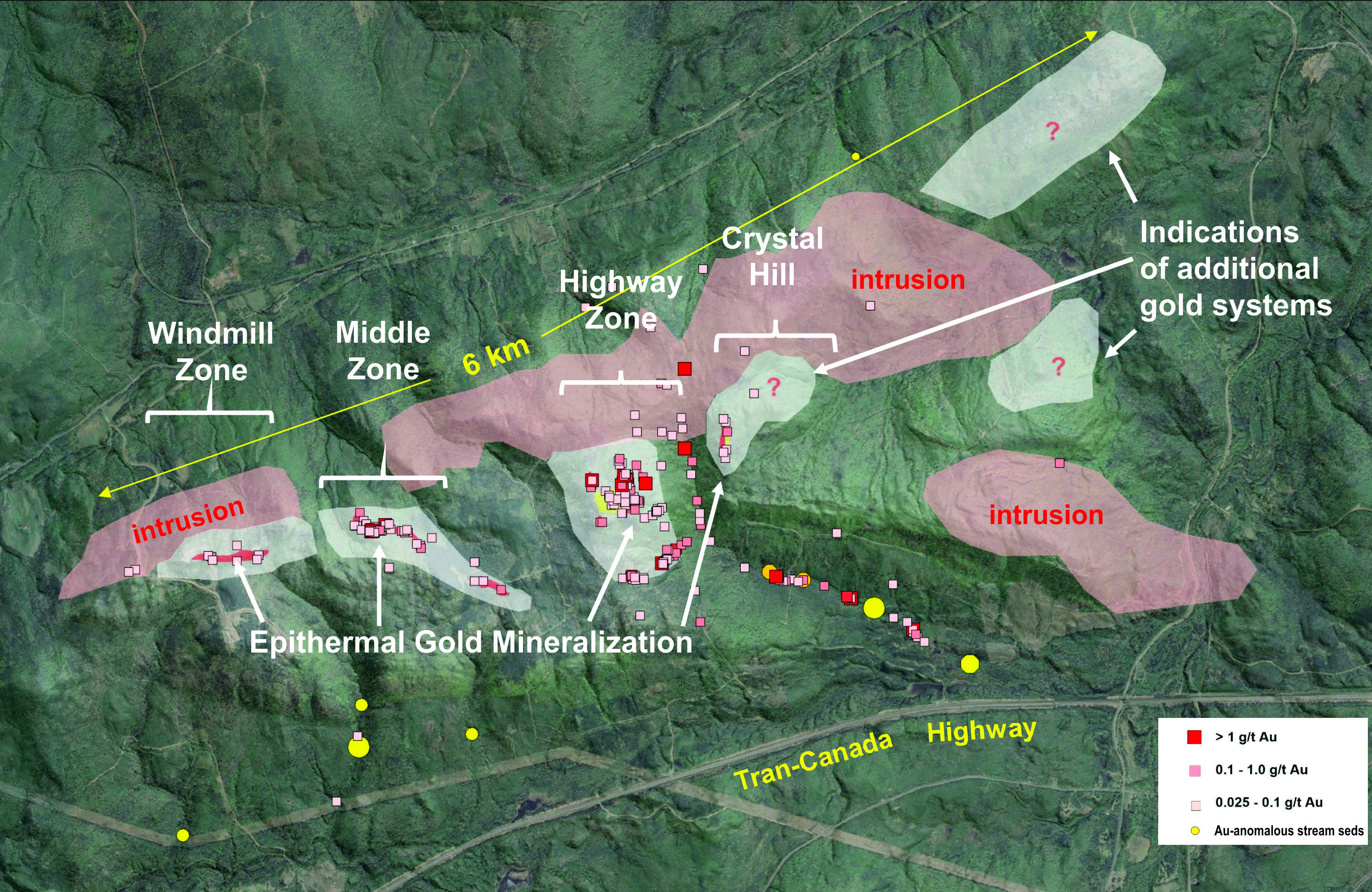
- identified highly anomalous gold in what is now termed the Highway Zone where much of the ground exploration has focused to date and where the inaugural drill program was conducted and produced gold assays up to 22.1 g/ton over 0.4 m;
- identified several other areas anomalous in gold and/or pathfinder elements associated with epithermal systems.
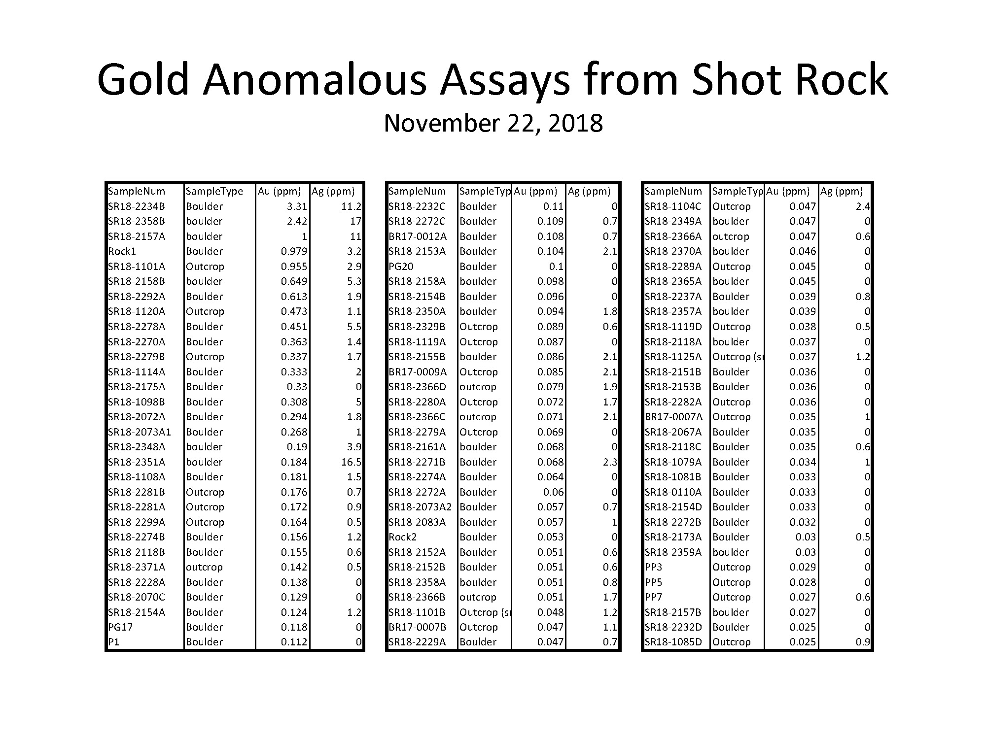
Prospecting in the Highway Zone to follow-up on the gold-anomalous stream sediment samples first identified a number of angular float samples of quartz vein material exhibiting classic low sulphidation epithermal textures. These included colloform and crustiform banding, bladed carbonate, comb textured quartz with jasper infilling and brecciated colloform chalcedonic quartz with japer fragments and selvages. Many of the rock samples of quartz vein material from the area returned anomalous gold assays (>25 ppb) with a high of 3.3 g/t Au.
Further prospecting and mapping quickly led to the discovery of large banded quartz veins and zones of stockwork-style epithermal quartz veins in outcrop returning assays up to 5.4 g/ton Au in grab samples.
Early studies of textures and mineralogy suggested a relatively high erosional level of the vein system, which is supported by what is observed in core after the first drill program.
Epithermal veins are known to exhibit strong vertical zonation in gold grades and associated elements. Particularly, gold may only show very weak enrichment (few tens of ppb) high in the system above the boiling zone, but can increase significant downwards within and below the boiling cap.
The gold grades observed at surface were suggestive of a much richer system not too far at depth and this has been confirmed with the identification of high-grade mineralization less than 200 m below surface. Eight drill holes for a total of 2,189 metres were completed in early 2020. This very first drill program was aiming at determining the geometry of the system, identifying which structures are gold bearing and validating the LSE model that gold grades increase significantly as a function of depth in the boiling zone. It also outlined pathfinders zonation/distribution in relationship with the gold-bearing vein system.
All data to date suggest a potential strike-length of the system of at least 4 km, possibly 6 km, and open at both ends.
The orientation of the gold-bearing structures, which was previously uncertain due to very limited surface exposure, is now also better understood. This will greatly assist in the targeting of follow-up drill holes. Specifically, valuable insight was gained from the robust and distinct halos of pathfinder elements associated with the gold mineralization. The Company believes that it has now isolated the structures that host the gold mineralization and has a much better understanding of the camp-scale regional features that influenced the location of the LSE gold system centered on the Highway Zone. This breakthrough delivers the geological opportunity that supports a large-scale and productive LSE gold system so the Company can now move forward confidently with further drilling.
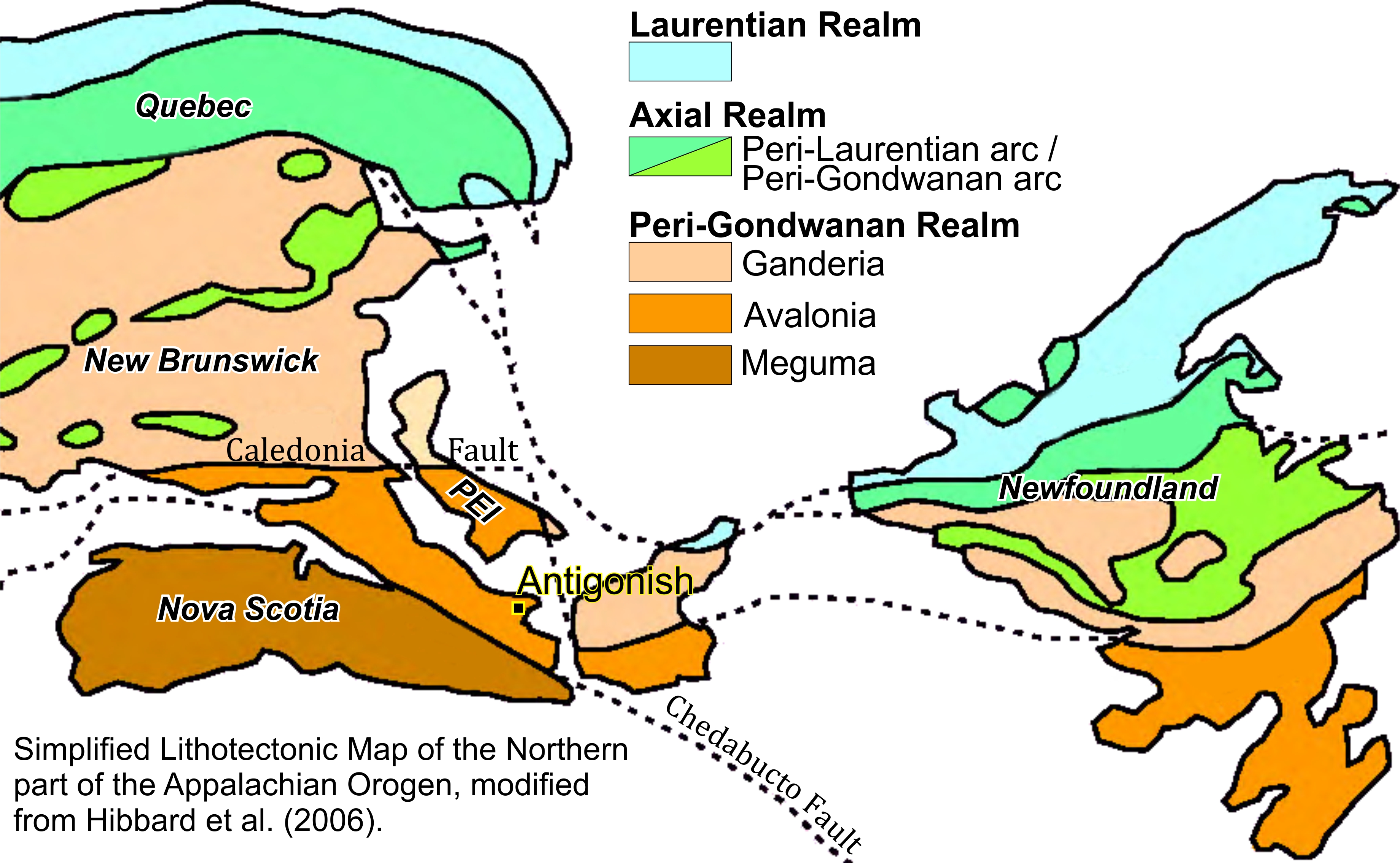
The Shot Rock Property is located in the Antigonish Highlands, along the southern margin of Avalonia, a fault-bounded terrane between the Meguma Terrane to the South and the Ganderia Terrane to the North throughout the northern Appalachian orogen.
The oldest rocks found within the Property are part of the Late Neoproterozoic Georgeville Group, including units from the Keppoch (rhyolites and dacites) and James River formations (sandstone and siltstones). The late Neoproterozoic Bears Brook formation overlies the Georgeville Group formations in what appears to be a somewhat conformable contact, at least within the area of the Property.
The rest of the Property is underlain by rocks from the Silurian Arisaig Group.
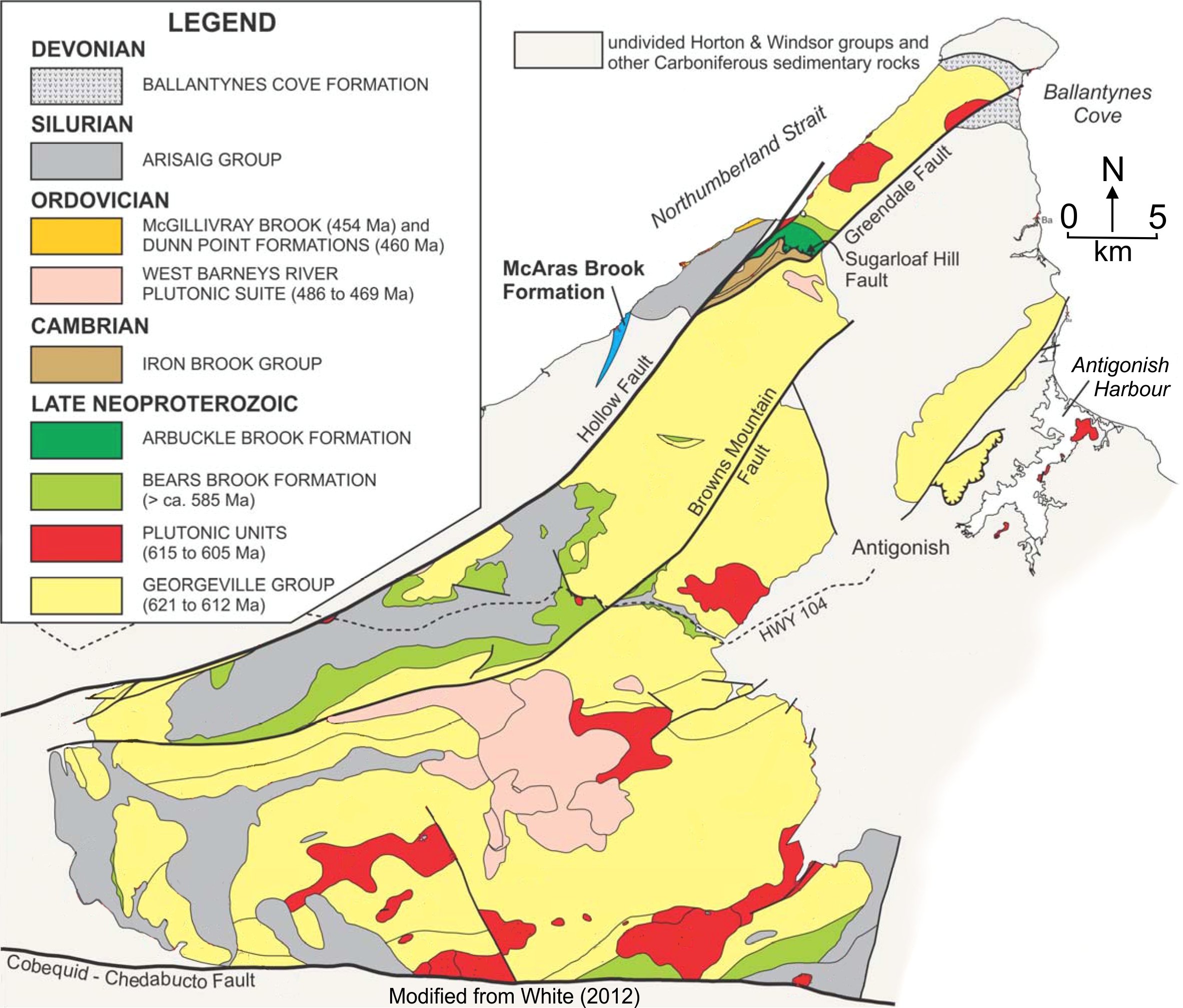
The underlying geology within the current area of interest for exploration (Highway Zone, Middle Zone, Windmill Zone, Crystal Hill and Patrick Zone) is largely composed of the Georgeville Group’s James River Formation. These rocks consist of green- to green-grey and maroon, well laminated mudstones and siltstones that are locally interbedded with light green cherty siltstones and light grey, fine- to medium-grained, well sorted sandstones. The laminated mudstones and siltstones show evidence of reworking processes including slumping, chaotic folding, cross-bedding and dewatering structures observed in dill core and in outcrop. The Bears Brook Formation red-brown to maroon pebble conglomerates and arkosic sandstones overly the James River Formation metasedimentary rocks. These conglomerates are locally observed to have rounded to sub-rounded sand- to pebble-sized clasts dominated by quartz and potassic feldspar with minor siltstone fragments and trace disseminated sulphides.
Multiple intermediate to mafic dikes and sills intruding the Georgeville Group metasedimentary rock were observed in the field and in drill core. These are green-grey to dark green, locally altered pink, amygdaloidal, with an aphanitic to fine-grained groundmass. Where alteration is less pervasive, alkali gabbros display equigranular textures and are variably magnetic, whereas the pervasively altered ones appear pophyritic in hand sample. Both altered and unaltered gabbros are consistently amygdular, with amygdules ranging in shape from rounded to amoeboid, typically 2 mm and up to 15 mm in diameter, variably filled with chlorite, quartz, pyrite and carbonates. The syenitic intrusions outcropping at surface are fine-grained, equigranular, typically non-magnetic and contain up to 70% subhedral potassic feldspars with lesser amphiboles, biotite, chlorite, quartz and minor disseminated sulphides constrained to the contacts with the country rock.
The sedimentary rocks of the Arisaig Group unconformably overly the rocks of the Georgeville Group and surround the zones of mineralized occurrences. These rocks consist of locally fossiliferous mudstones, minor dark purple slates, quartz arenites and red to purple pebble conglomerates. The fossiliferous sedimentary rocks range from dark grey-brown mudstones and purple slates to very fine-grained, muddy, micaceous sandstones gradually transitioning to a light grey, very fine- to fine-grained, micaceous quartz arenite. The red to purple conglomerates are thickly bedded, medium- to coarse-grained, rounded to subangular and contain dominantly potassic feldspar and quartz fragments with minor fine-grained granitic clasts. Beds show a gradational change with coarser lenses dominated by rounded red and grey siltstone and finer lenses dominated by fine-grained angular potassic feldspar fragments. Overturned bedding is evident from a fining downward sequence observed in outcrop.
About Epithermal Gold
The following description is mostly based on a thorough compilation paper by Simmons et al. (2005), in which references to a large number of relevant papers can be found.
Epithermal systems have been and continue to be a very important source of gold and even more important source of silver. The typical orebody found in an epithermal system varies in shape, size and grade, and can easily be hidden underneath a blanket of barren alteration or even unaltered volcanic rocks. Deposit-size to district-size range from <10 km2 to 200 km2.
Drilling is crucial in exploring for epithermal deposits because surface features may not be representative of what is at depth.
Efficient exploration must include the integration of the following at every scale, from deposit to regional:
- Geological data – vein mineralogy and texture, patterns of hydrothermal alteration
- Geochemical data – patterns of dispersion
- Geophysical data – three dimensional signatures
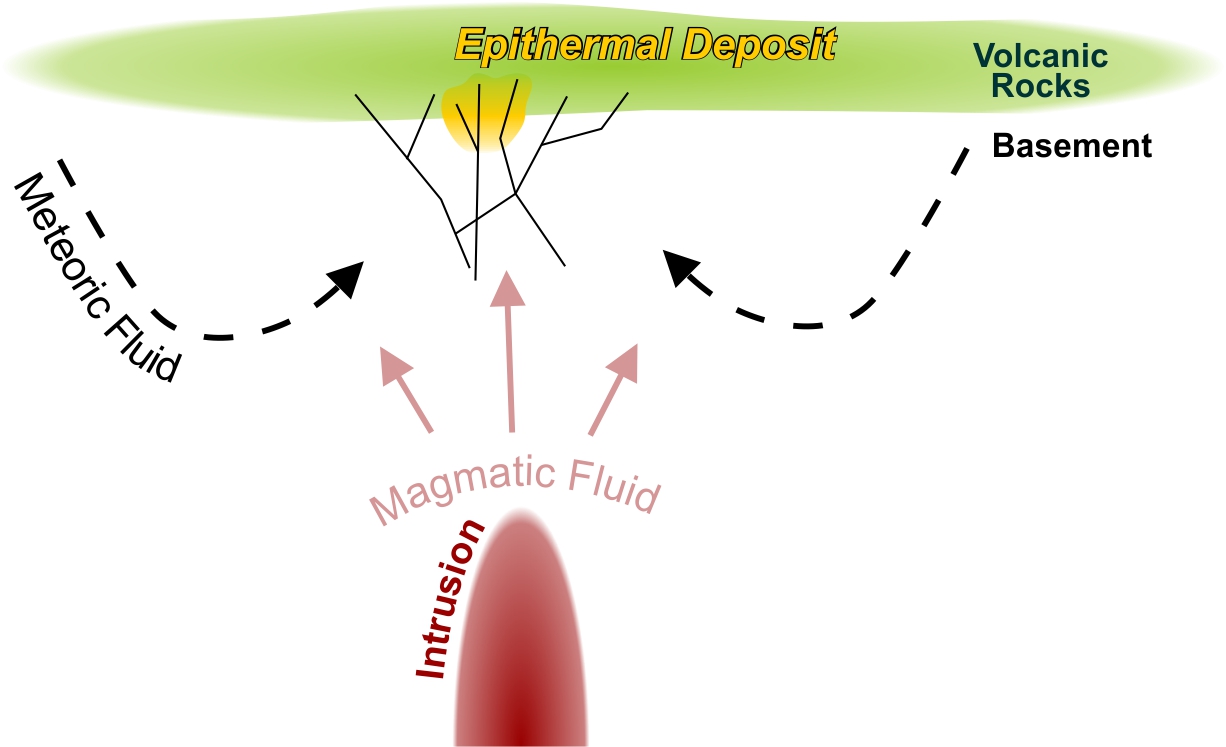
Deposits form in the lower temperature, shallow portion (< 1.5 km depth and < 300° C) of a high temperature hydrothermal system.
This type of hydrothermal system most commonly develops in association with magmatic sequences of andesite, dacite and rhyolite of calc-alkaline and alkaline affinity, which are related to volcanic arc at convergent margins, intra-arc, back-arc and postcollisional rift settings. Au-rich deposits (low Ag/Au ratio) are also found in tholeiitic bimodal (basalt-and rhyolite) systems.
The mineralization develops in zones of high permeability within the volcanic rocks genetically related to the hydrothermal system and in the older basement rocks below them. Steep dipping veins are generally host to the highest-grade ore. Lower-grade but potentially high tonnage ore can also be found in breccias, coarse clastic rocks and intensely leached rocks.
Epithermal deposits are historically classified based on either:
- Alteration and gangue mineral assemblages
- Metal content
- Sulphide content
- Sulphide mineral assemblages
The first is generally preferred because potentially high degree of oxidization of the ore can make the other three methods difficult.
Two main types or mineral assemblages reflecting pH of hydrothermal solutions are recognized:
1. Mineralization associated with quartz ± calcite ± adularia ± illite
- Au-Ag, Ag-Au or Ag-Pb-Zn
- Au and Ag in electrum, acanthite, silver sulfosalts, silver selenides and Au-Ag tellurides
- Sphalerite, galena and chalcopyrite generally minor but occasionally dominant
- Quartz is main gangue, other minerals are chalcedony, adularia, illite, pyrite, calcite and/or rhodochrosite (in Ag-base metal rich deposits)
- Banded, cruciform-colloform textures, lattice textures of platy calcite and their quartz pseudomorphs
- Hydrothermal alteration is zoned from bottom to top:
- Deep regional propylitic
- Increasing amounts of clay, carbonate and zeolite minerals
- Proximal enveloping orebody is quartz, adularia, illite and pyrite
- Mineralization can be concealed under a regional alteration blanket of clay-carbonate-pyrite or kaolinite-alunite-opal ± pyrite
2. Mineralization associated with quartz ± alunite ± pyrophyllite ± dickite ± kaolinite
- Au ± Ag ± Cu ores
- Au and Ag as native gold and electrum
- Variable amounts of pyrite, Cu-bearing sulphides (mainly enargite, a high sulfidation indicator) and sulfosalts, sphalerite and telluride minerals
- Main gangue is massive and vuggy quartz and alunite, other minerals are kandite minerals (dickite and/or kaolinite) and/or pyrophyllite
- Hydrothermal alteration forms concentric envelops, from inside out:
- Ore-hosting vuggy and massive quartz
- Alteration zone of quartz and alunite, dickite ± kaolinite or pyrophyllite and illite or smectite
- Regional propylitic alteration
- Zone of illite or pyrophyllite alteration may occur in the roots below deposit
References
Hibbard, J P, van Staal, C R, Rankin, D W, Williams, H. 2006: Lithotectonic map of the Appalachian Orogen, Canada-United States of America. Geological Survey of Canada, "A" Series Map 2096A, 2 sheets, https://doi.org/10.4095/221912
Simmons, S.F., White, N.C. and John, D.A., 2005. Geological characteristics of epithermal precious and base metal deposits. Economic Geology 100th Anniversary Volume, pp. 485-522.
White, C. E. 2012: Preliminary geology of the Antigonish Highlands, northern mainland Nova Scotia; in Mineral Resources Branch, Report of Activities 2011, ed. D. R. MacDonald and E. W. MacDonald; Nova Scotia Department of Natural Resources, Report ME 2012-001, p. 75-91. https://novascotia.ca/natr/meb/data/pubs/12re01/12re01_14White.pdf
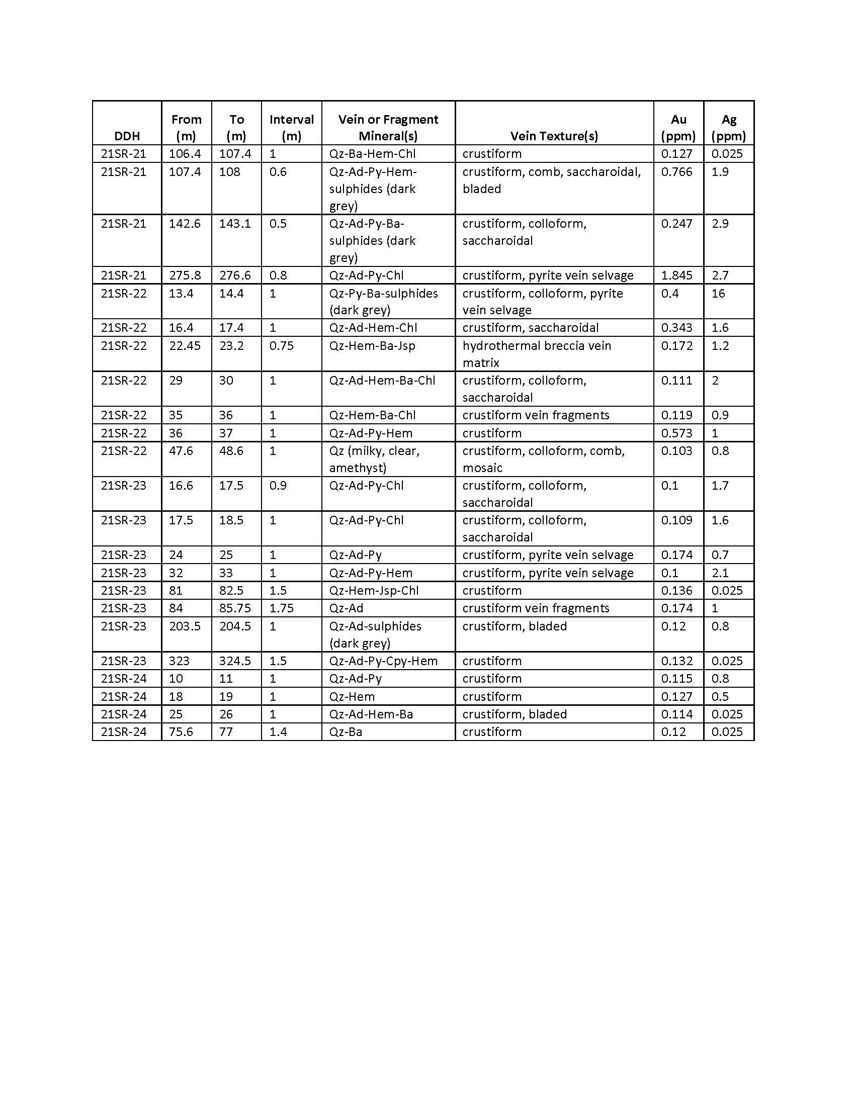
Assay Table - June 15, 2021
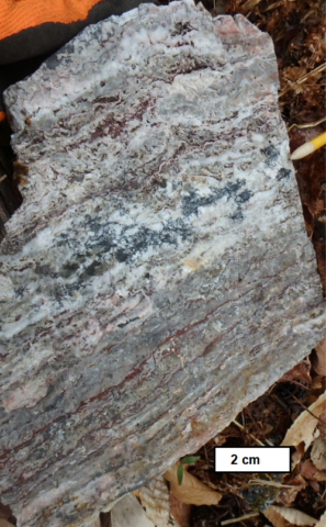
Core samples (Fig. 1-4) taken during the second drill program at Shot Rock, July 2020.
Fig. 1
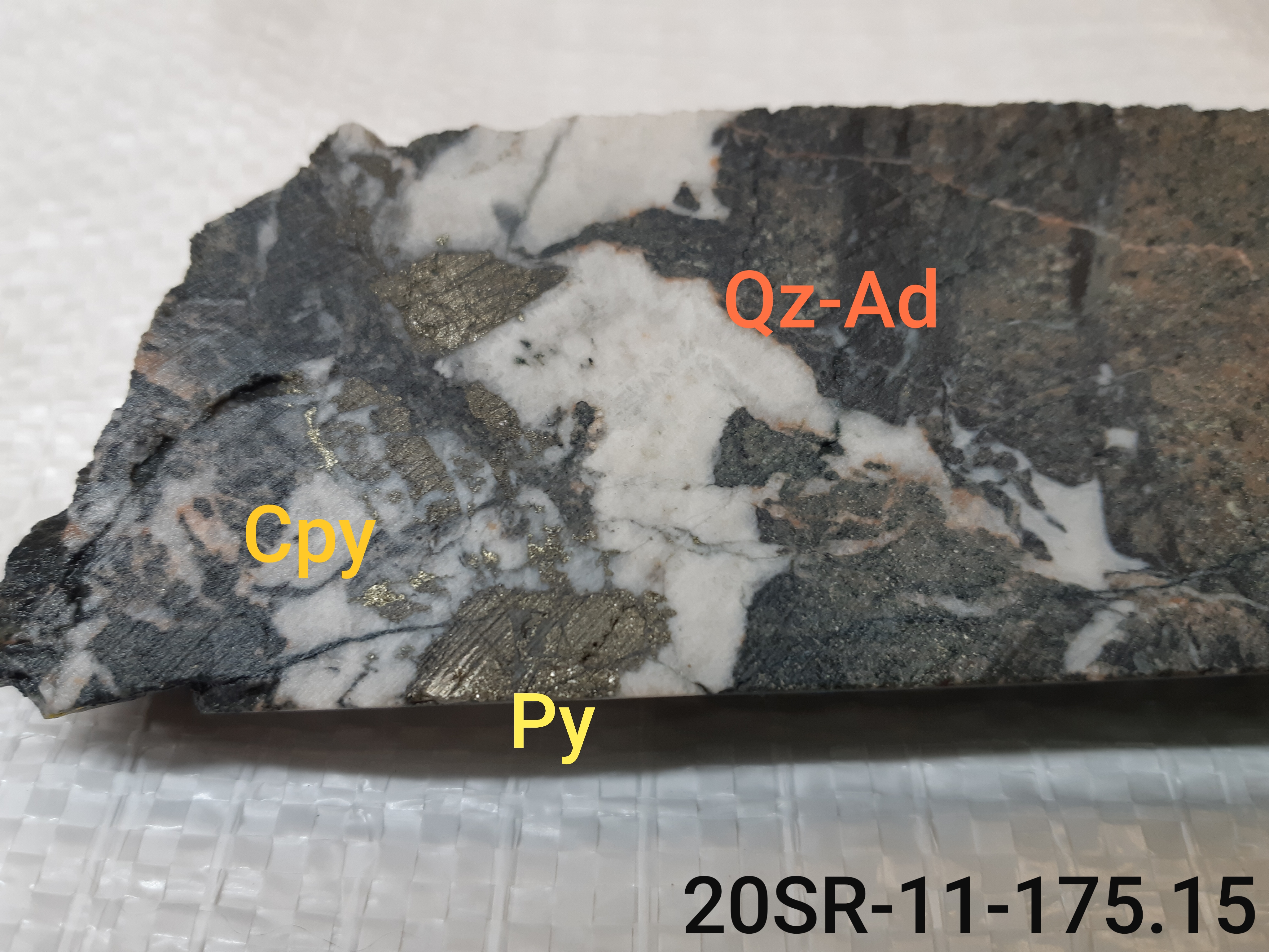
Fig. 2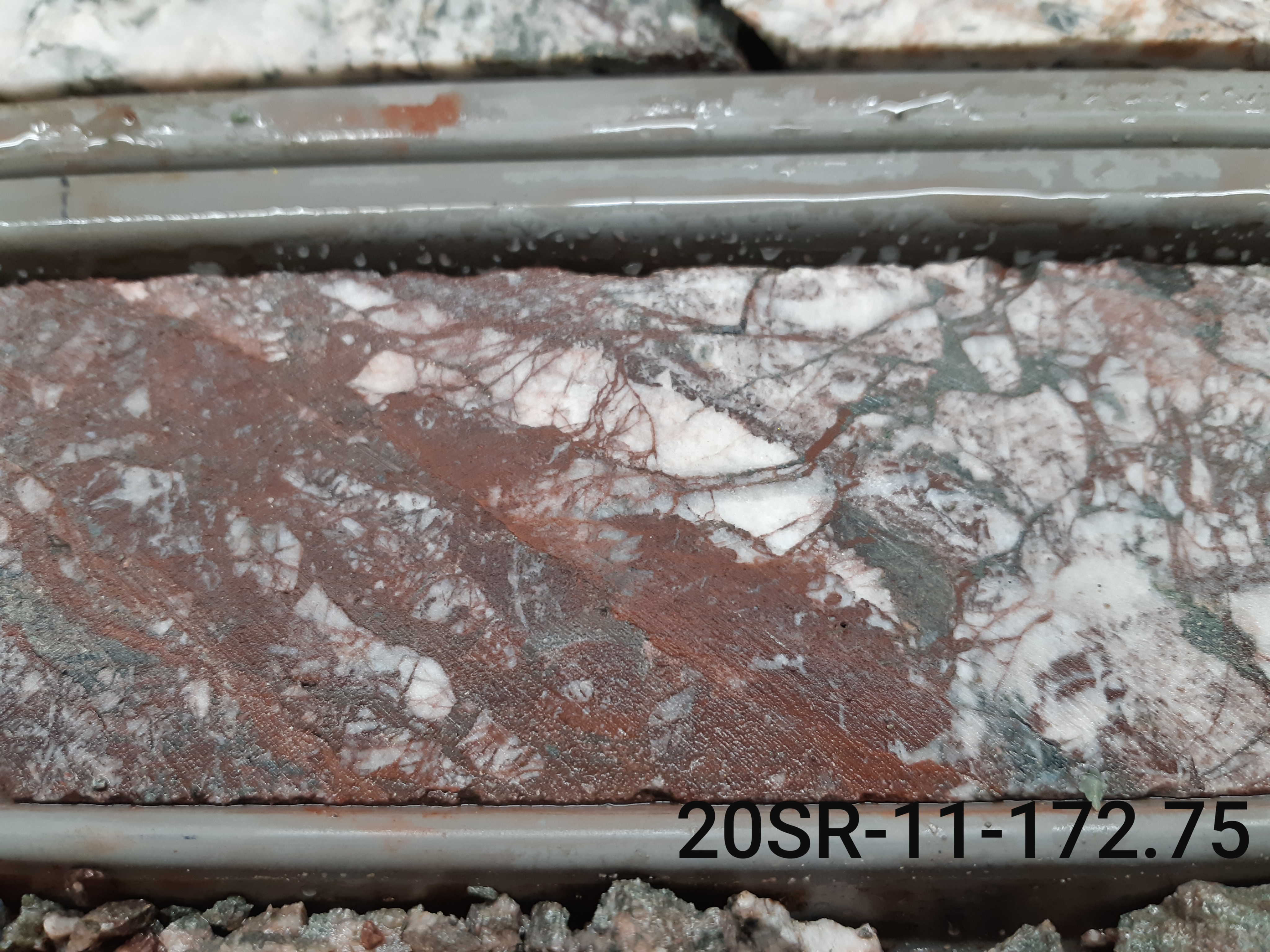
Fig. 3
Fig. 4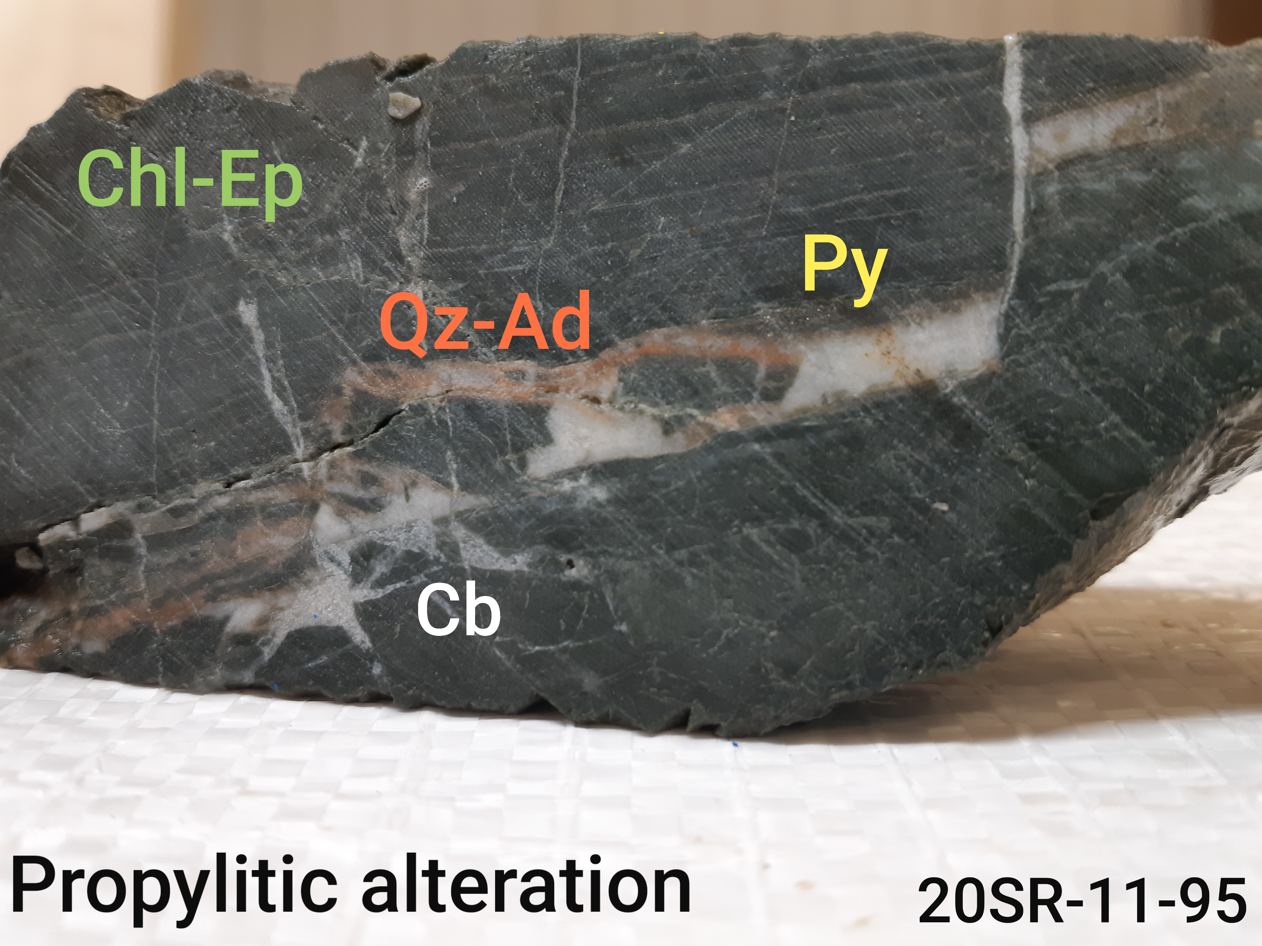
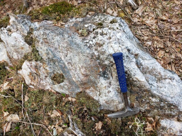
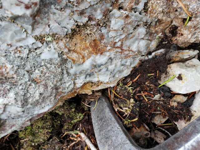
Surface samples collected from Shot Rock exhibiting variably banded epithermal quartz vein textures.
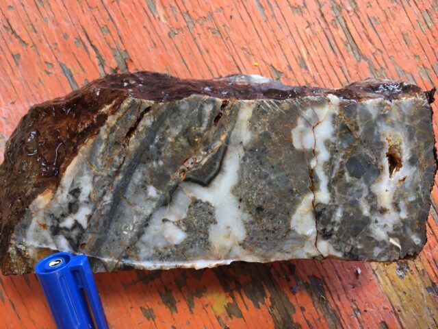
Banded and brecciated quartz vein with possible ginguro band and fragments of acid altered wall-rock.
Acid alteration of wall-rock of bornite bearing quartz vein.
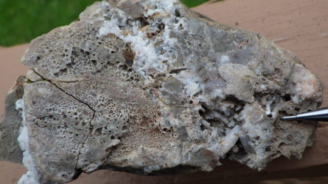
Quartz-hematite-chalcedony breccia.

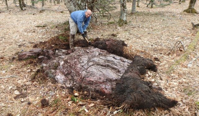
Shot Rock discover, prospector Patrick Bellefontaine.