IDEFIX (Ni-Cu-PGE) Labrador Trough, Québec
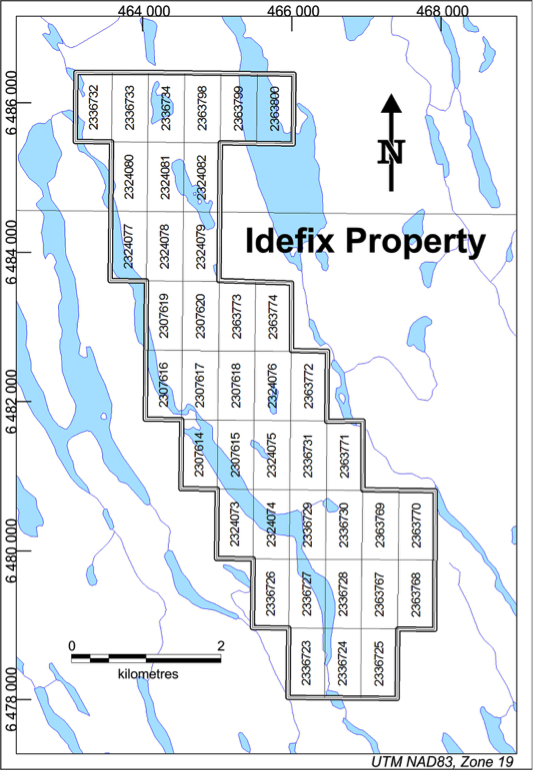
The Idefix Property is located 75 kilometres northwest of the Community of Kuujjuaq, in the Nunavik region of the province of Quebec. Northern Shield currently holds a 100% interest in the Idefix Property, which currently consists of 40 claims covering 18 km2. The first claims at the Idefix Property were staked in August 2011 over an area of known PGE mineralization, following on the work conducted by previous exploration companies and on regional prospecting by Northern Shield in the northern Labrador Trough in the summer of 2011. Exploration at the Idefix Property is supported by helicopter from Kuujjuaq with fishing and hunting lodges acting as site bases.
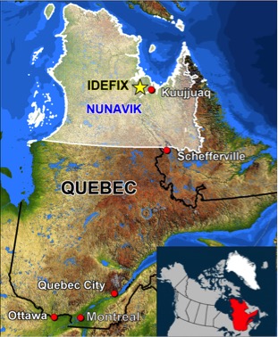
The Raglan Nickel belt, which is being mined by Glencore/Xstrata and Canadian Royalties, is located another 500 km further northwest of Idefix. The Labrador Trough is located at the edge of the Superior Craton, an ideal location for magmatic deposits to form. It is directly analogous to the western Yilgarn Craton in Australia, where the world class Julimar Ni-Cu-PGE deposit was recently discovered.
The original exploration focus at the Idefix Property was for reef-type PGE mineralization after the discovery of significant and extensive PGE mineralization in 2012 along a gabbronorite escarpment with grades up to 16 grams per tonne of platinum and palladium at a ratio of 1:3. However, during 2014 and 2015, significant advancements were made by Northern Shield in understanding the geology and geochemistry of the Idefix Property. The presence of large nickel-copper-PGE bearing sulphide globules seen in nearly every drill hole completed along the Idefix Ridge points to the possible existence of massive magmatic sulphides similar to a Noril’sk type model.
Geologically, the Idefix Property is found within the Labrador Trough, a Paleoproterozoic supracrustal sequence located at the eastern margin of the Superior Province. The sequence was folded and metamorphosed during the New Quebec Orogen, which represents the collision between the Superior Craton and the Core Zone of the Southeastern Churchill Province. The Labrador Trough is over 500 kilometres long and is composed of three cycles of sedimentation and volcanism (Clark and Wares, 2005), separated by erosional unconformities. Each cycle is further subdivided in groups and formations.
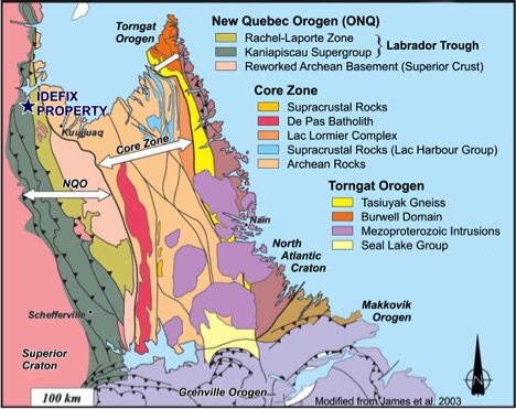
The first two cycles are intruded by numerous tholeiitic, mafic-ultramafic sills referred to as the Montagnais sills. These sills are contemporaneous and comagmatic with associated volcanic rocks. The mineralization at the Idefix Property is found in one of those mafic-ultramafic sills.
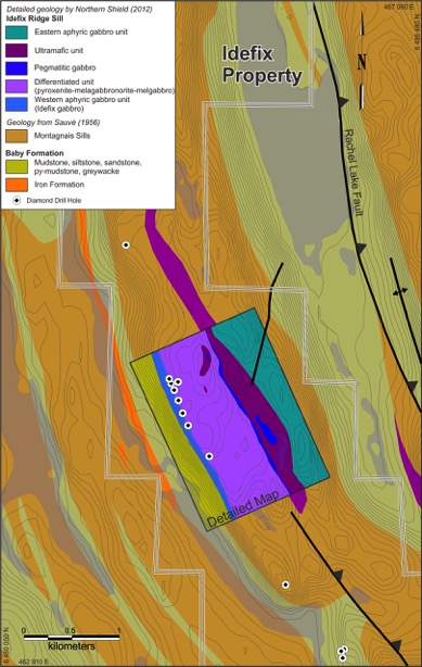
Airborne reconnaissance surveys conducted in the 1940s identified numerous gossanous outcrops, later identified to be magmatic Ni-Cu-PGE showings. In the 1950s, several companies conducted field reconnaissance and geophysical surveys near Idefix and they identified several Ni-Cu showings (Sogemines Development Company, 1962; Schilling, 1963; De Freneuse, 1965). Cities Service Minerals Corporation reported the first PGE values near Idefix, in rocks grading 11.22% Cu, 0.04% Ni, 3.43 g/t Pt and 10.28 g/t Pd (Loring, 1975).
La Fosse Platinum Group conducted extensive Ni-Cu-PGE exploration along the eastern half of the NQO during the 1980s. They first identified mineralization at Idefix, then named Ukunngaalik, where gabbros grading 0.77 g/t Au, 2.73 g/t Pt and 5.77 g/t Pd (Avison, 1986; La Fosse Platinum Group, 1988). The area was not explored further until 2002, when Virginia Resources identified additional strata-bound sulfide mineralization that had grades up to 18.10 g/t Pd+Pt+Au (Savard, 2003).
After a year of thorough desktop studies and research on the northern Labrador Trough, in early September 2011, Northern Shield conducted a two-day reconnaissance exploration program on the Idefix Property. Twenty-five rocks samples were collected of which 21 were from the mafic-ultramafic sill and four from the country rock. Nine of the 21 samples collected from the mafic-ultramafic sill returned assays greater than 1 g/t Pt+Pd+Au with a high of 8.8 g/t Pt+Pd+Au.
During the three phases of the 2012 exploration season, the results continued to show the Idefix Property as a target with potential to host a viable PGE deposit based on some high-grade PGE values and the continuous nature of the mineralization. The Idefix PGE mineralization at that time could be traced over 1.3 kilometres. Many of the higher-grade PGE assays were sawn channel samples taken over widths of 1 metres including 15.6, 10.5, 7.6 and 6.4 g/t Pt+Pd.
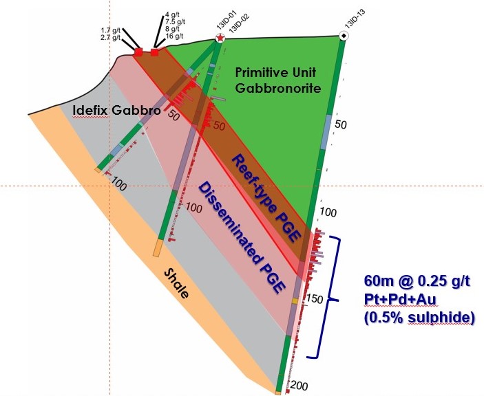
In 2013, fourteen drill-holes totalling 1,501 metres were completed at Idefix. Drilling did not intercept similar grades of PGEs as seen on surface but did prove the existence of reef type mineralization averaging 0.2-0.4 g/t PGE over 16-34 metre widths that can be traced continuously for 3.5 kilometres and intermittently for up to 7 km. Of the 1,614 samples collected at Idefix, 934 assayed greater than 0.1 g/t Pt+Pd+Au, highlighting the significant enrichment of PGE at Idefix. Drilling also revealed the presence of large sulphide globules along the entire length of the Idefix Ridge.
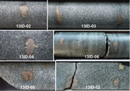
Additionally, in 2013, significant PGE mineralization was discovered 900 meters immediately south of the Idefix Ridge. This area called “La Colline” includes a PGE-enriched zone defined by 34 continuous sawn channel samples which average 1.4 g/t Pt+Pd+Au, 0.28% Cu and 0.1% Ni over 31.35 metres. Samples at La Colline display interstitial and net-textured sulphides. The geochemical signature of the mineralization at La Colline is commonly associated with nickel-copper massive sulphides and one of the key indicators for a Noril’sk-type deposit at Idefix.
After reviewing all accumulated information at the Idefix Property, new interpretation based in part on the presence of sulphide globules along the Idefix Ridge and net-textured sulphides at La Colline suggest, with a high degree of confidence, that the reef-type mineralization was the result of the redistribution of nickel-copper-PGE sulphides in the magma from a massive sulphide source somewhere nearby in the sill. It also implies that PGE-rich nickel-copper massive sulphides (Noril’sk-type) should now be the primary target model.
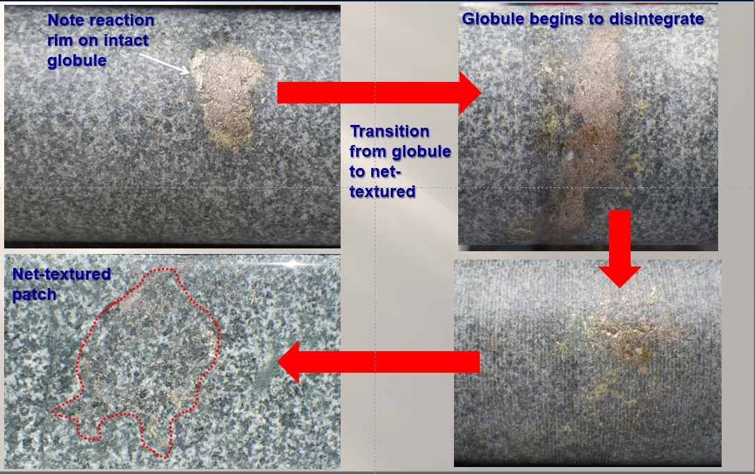
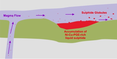
Globules are blebs of sulphide that have been transported away from a pool of massive sulphide over relatively short distances by an injecting pulse of magma during sill emplacement while the sulphides and host rock were still molten. The globules are delicate and rapidly deteriorate with distance from the source, meaning that the larger and more cohesive globules will be the closest to the massive sulphide source.
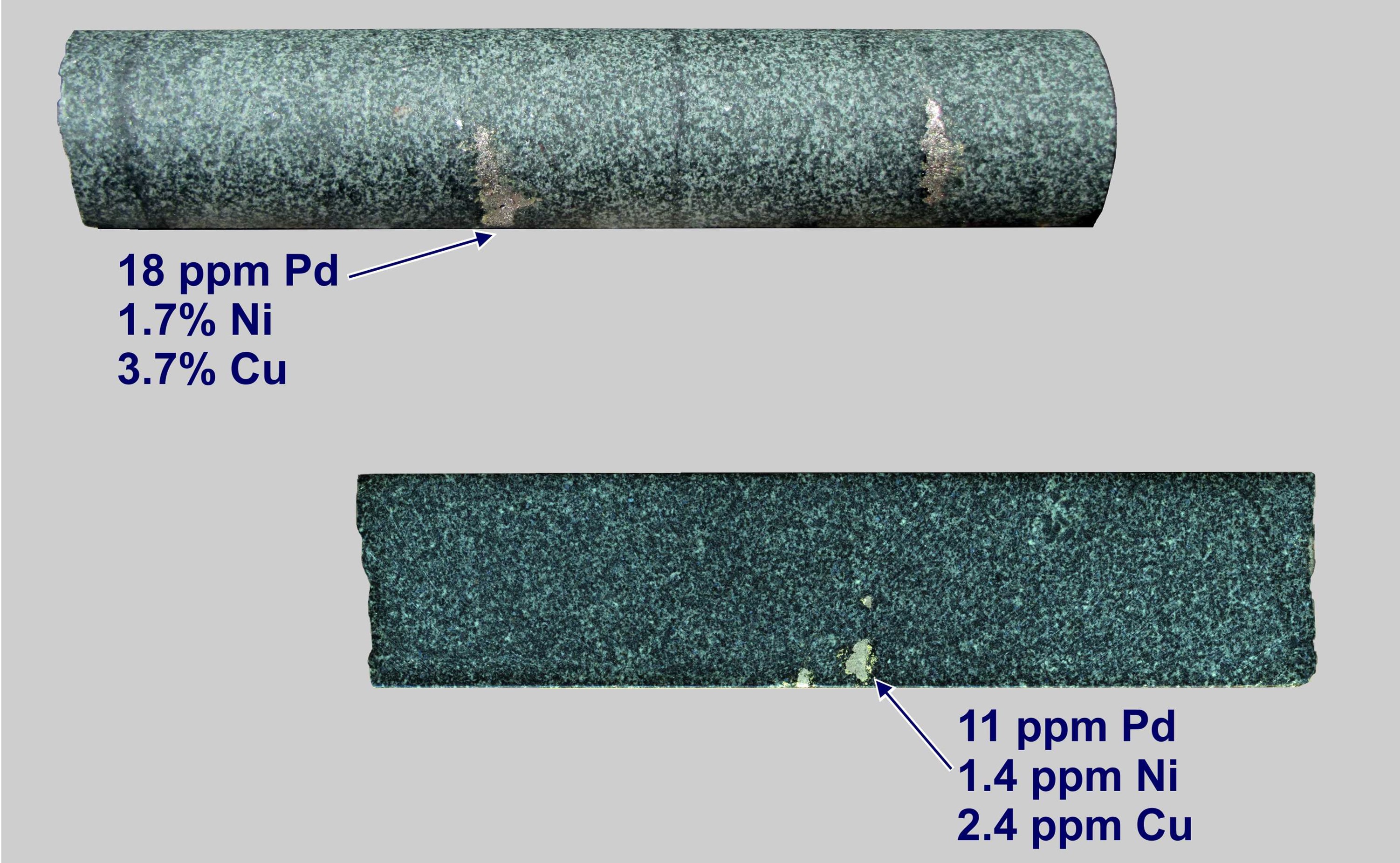
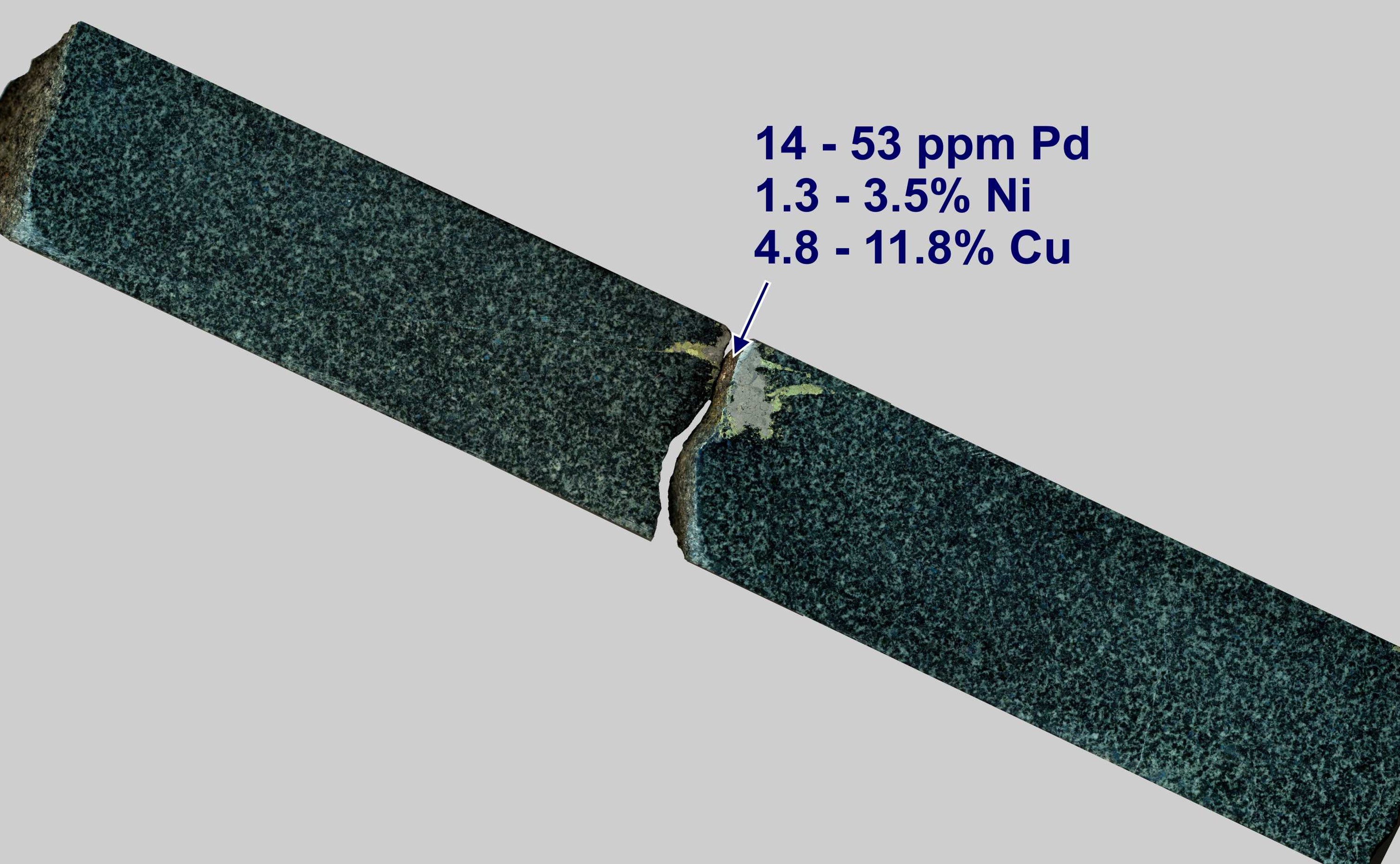
The globules at Idefix can reach up to 3 centimetres in diameter and contain an average of approximately 1% nickel, 3% copper and 9 g/t palladium (n=53 on 11 globules) with globules averaging as high as 2.5% Ni, 6% copper and 27 g/t palladium as indicated by portable X-ray Spectrometer (Innov-X Systems - X-50 Portable XRF). It is important to note that the Portable XRF unit does not have the capability to detect platinum at the level present in the samples. As platinum to palladium ratios at Idefix are approximately 1:3, the platinum values should be estimated at one third of the palladium values.
Because the Idefix Property was explored mostly for a reef-type PGE deposit, i.e., a low sulphide system, an EM geophysical survey was not considered originally. With the new interpretation suggesting the proximity of a massive sulphide body, a VTEMÔ survey was conducted during the summer of 2016.
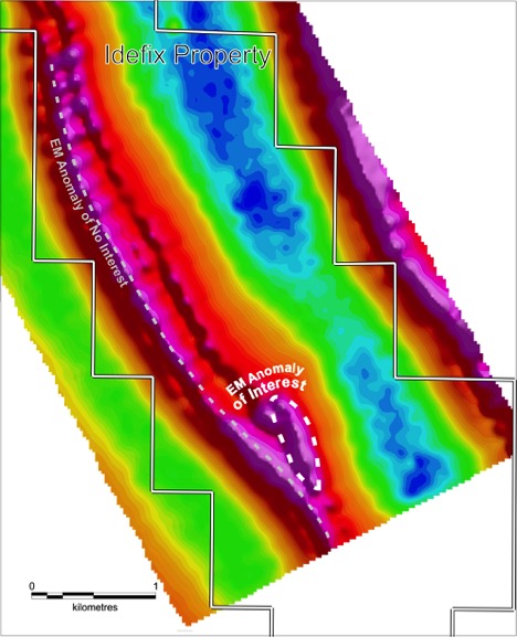
The geophysical survey highlights a long continuous conductor along the base of the Idefix Ridge, which results from the high conductivity of the graphitic sedimentary units underlying the Idefix mafic-ultramafic sill. However, there is another very interesting anomaly located between La Colline and the southeast end of the Idefix ridge that could very well underline a massive sulphide body. Unfortunately, drilling in 2013 would have missed this conductor and so it remains unexplained to date. Concentrations of sulphide globules in large blocks of rocks that have fallen from the very steep south facing end of the ridge were observed but the possibility of more falling blocks was considered too high a risk to continue prospecting along that face. Northern Shield hopes to conduct a short drill program at Idefix to test this conductor in the near future.
Avison, A. T. (1986). Report on 1986 Exploration Program in the Labrador Trough. Geological Association of Canada.
https://gq.mines.gouv.qc.ca/documents/examine/GM45371/GM45371.pdf
De Freneuse, S. W. (1965). A Report on the Gravity Survey.
https://gq.mines.gouv.qc.ca/documents/examine/GM16176/GM16176.pdf
James, D.T., Nunn, G.A.G., Kamo, S. and Kwok, K. 2003. The southeastern Churchill Province revisited: U-Pb geochronology, regional correlations and the enigmatic Orma Domain. Current Research, Newfoundland Department of Mines and Energy, Geological Survey Report 03-1, p. 35-45.
http://www.nr.gov.nl.ca/nr/mines/geoscience/publications/currentresearch/2003/james_nunn.pdf
La Fosse Platinum Group. (1988). Report on 1987 Exploration Results on Permits 809, 810, 811 Lac De Freneuse District.
https://gq.mines.gouv.qc.ca/documents/EXAMINE/GM47541/GM47541.pdf
Loring, W. B. (1975). Report on the Big “M” Property, Labrador Trough. Ministere Des Richesses Naturelles.
https://gq.mines.gouv.qc.ca/documents/EXAMINE/GM30647/GM30647.pdf
Map CG SIGEOM24K available on E-Sigeom – Examine database, Ministère de l’énergie et des ressources naturelles du Québec.
http://gq.mines.gouv.qc.ca/documents/examine/CG24K201101/CG24K201101PLAN.pdf
Savard, M. (2003). Labrador Trough Project: Summer 2002 Technical Report.Clark, T. and Wares, R.P. 2005. Lithotectonic and metallogenic synthesis of the New Québec Orogen (Larbrador Trough). Ministère des Ressources naturelles, Québec, MM 2005-01, 135 p.
http://gq.mines.gouv.qc.ca/documents/examine/MM200501/MM200501.pdf
Schilling, J.-G. (1963). Report on West Anderson Lake Group.
https://gq.mines.gouv.qc.ca/documents/EXAMINE/GM14675/GM14675.pdf
Sogemines Development Company. (1962). Ungava Gossans Project Geological Report.
https://gq.mines.gouv.qc.ca/documents/EXAMINE/GM13574/GM13574.pdf
At the Idefix Property, the host sill is about 600 metres thick, and dips 60° to the east. Both Cr/V and MgO trends throughout the sill indicate that the intrusive stratigraphic sequence at Idefix is overturned. The sill appears to be part of a fractionated mafic-ultramafic event with the stratigraphically lower Primitive Sequence consisting of medium to fine-grained melagabbronorite, olivine melagabbronorite and pyroxenite. The Idefix unit, dominantly consisting of gabbro, stratigraphically overlies the Primitive Sequence and is interpreted to represent a new pulse of magma into the sill. It tapers from 100 metres thick in the north to 60 metres at the south end of Idefix Ridge. The Idefix unit can be subdivided into the Lower, Upper and the Roof sub-units, though the latter may be a third unit of its own. The Roof sub-unit is in contact with sedimentary rocks dominated by shales, mudstones and quartzites with occasional cubic pyrite.
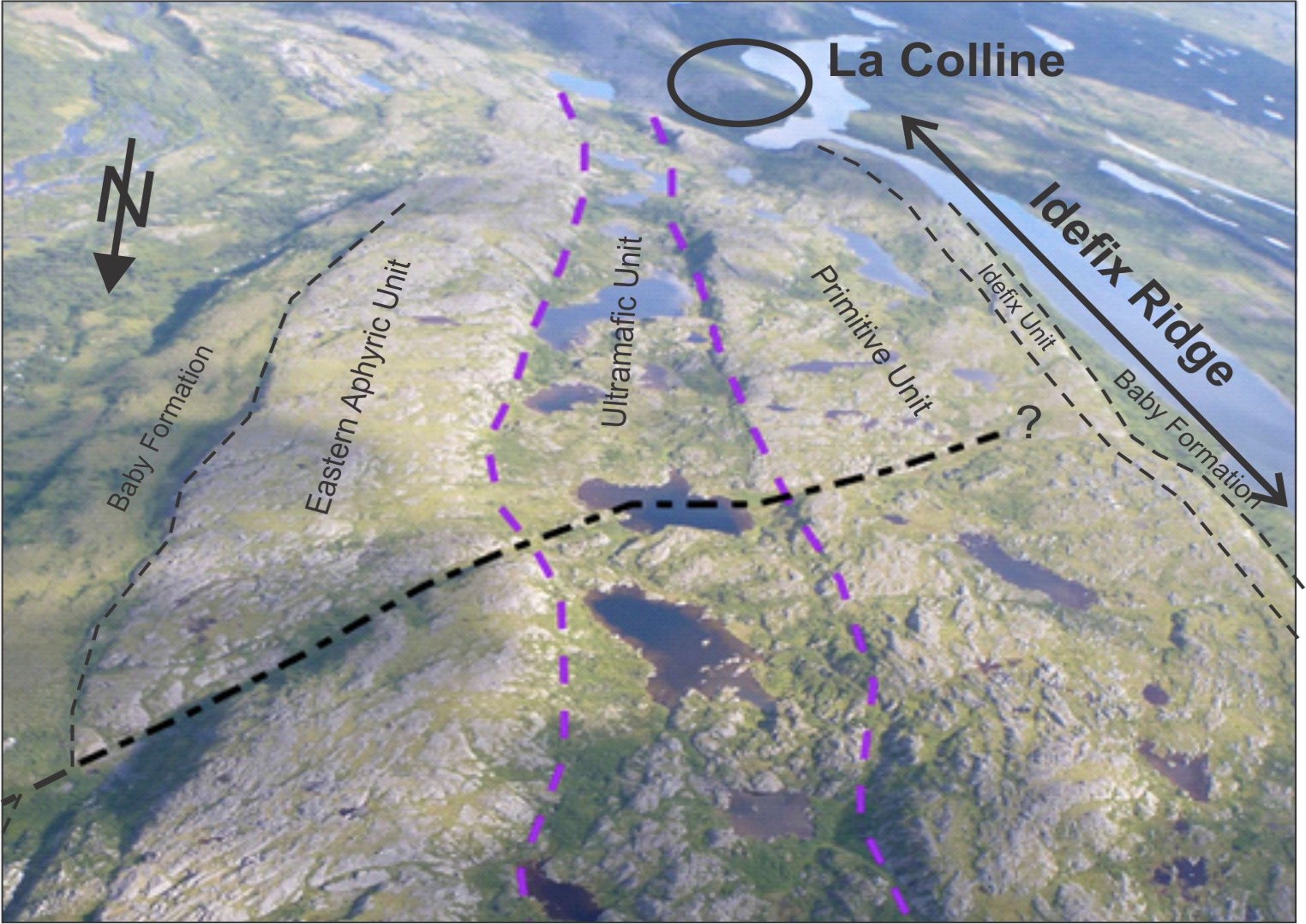
Summary
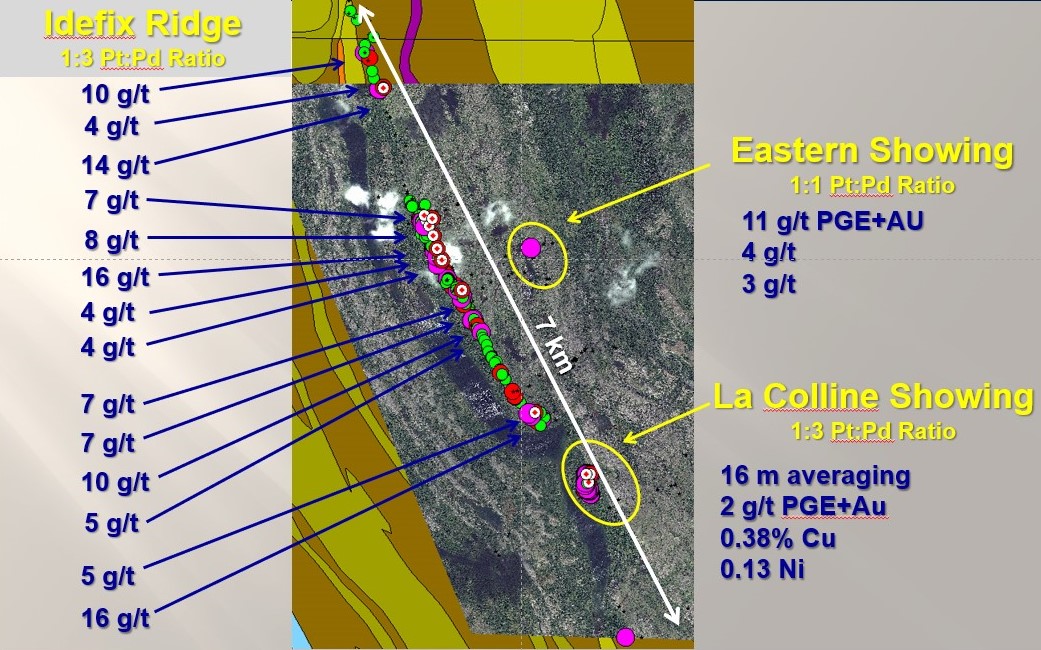
Mineralization at Idefix occurs within a composite sill, comprising a gabbroic unit (named the Idefix sill), which is underlain by sulfidic metasediments of the Baby Formation and overlain by a mela-gabbronorite unit named the Primitive Unit (PU). To date, 1,501 m of diamond drilling has been completed (14 drill holes), revealing a reef-type mineralized interval with an average grade of 0.2-0.4 g/t PGE+Au over 16-34 m, traceable for approximately 7 km along strike. If disseminated mineralization above the reef is included, the thickness of the mineralized interval increases to approximately 50 meters with grades averaging around 0.2 to 0.25 g/t PGE+Au. Out of 745 grab and channel samples, 499 assayed > 0.1 g/t PGE+Au with a high of 16/g/t PGE+Au. Furthermore, 900 m south of Idefix is the La Colline showing, where channel samples yielded average grades of 1.4 g/t PGE, 0.28% Cu and 0.13% Ni over 31.34 m. At La Colline, 41 of 92 channel and grab samples assay greater than 1 g/t PGE+Au.
Four different styles of PGE mineralization are observed:
(i) reef-type,
(ii) disseminated (including patchy net-texture),
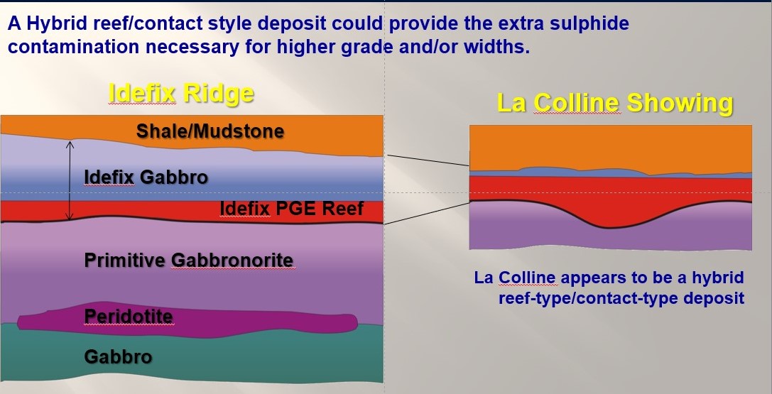
(iii) hybrid reef-contact type (La Colline) and
(iv) irregularly distributed globules of sulphide.
Reef-type Mineralization
All eleven of the drill-holes completed by Northern Shield in 2013 along the Idefix Ridge and covering a strike length of over two kilometres show that the main PGE mineralization at Idefix is located at the interface of the Primitive and Idefix units. The mineralization is considered reef-type based on its lateral continuity, stratiform nature at the contact between distinct geological phases, and its geochemical profile (see images). The reef ranges in thickness from about 16 metres to 34 metres with grades ranging from 0.26 to 0.4 g/t Pt+Pd+Au over those widths. The reef is interpreted to have formed from the interaction of the sulphide and PGE rich Idefix Gabbro magma with the underlying Primitive Sequence, which is also PGE-rich (~50 ppb PGE).
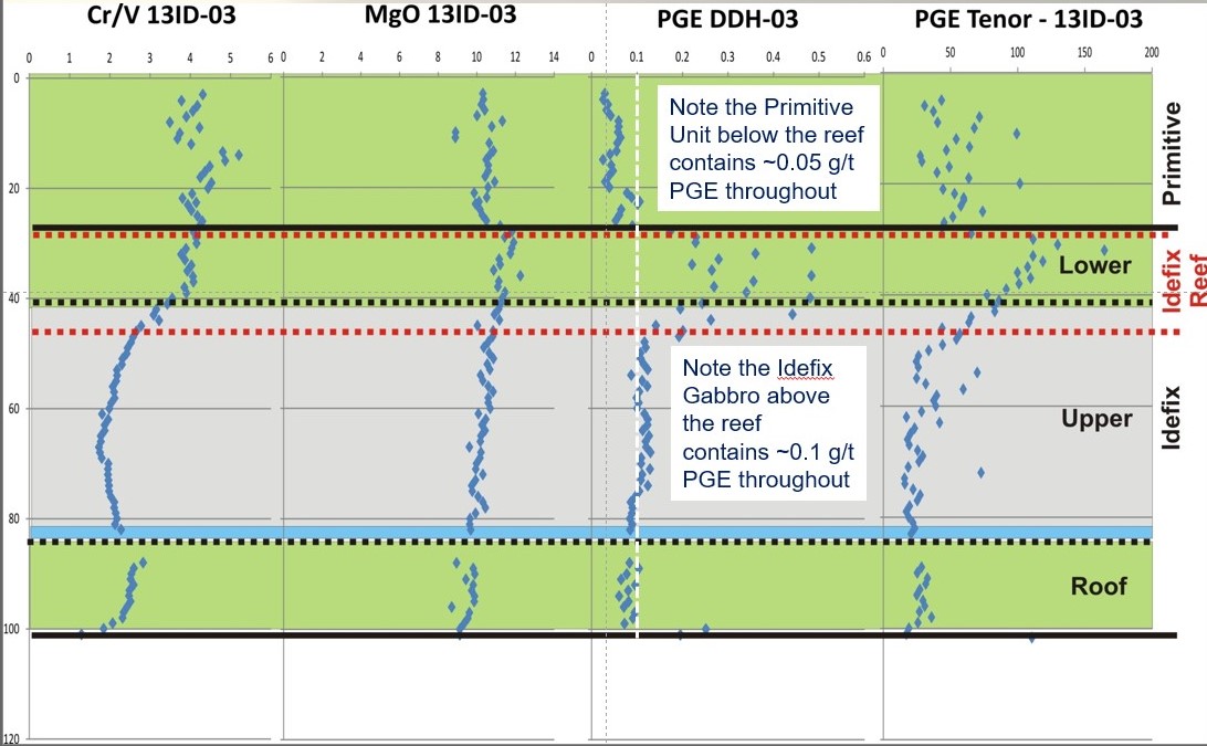
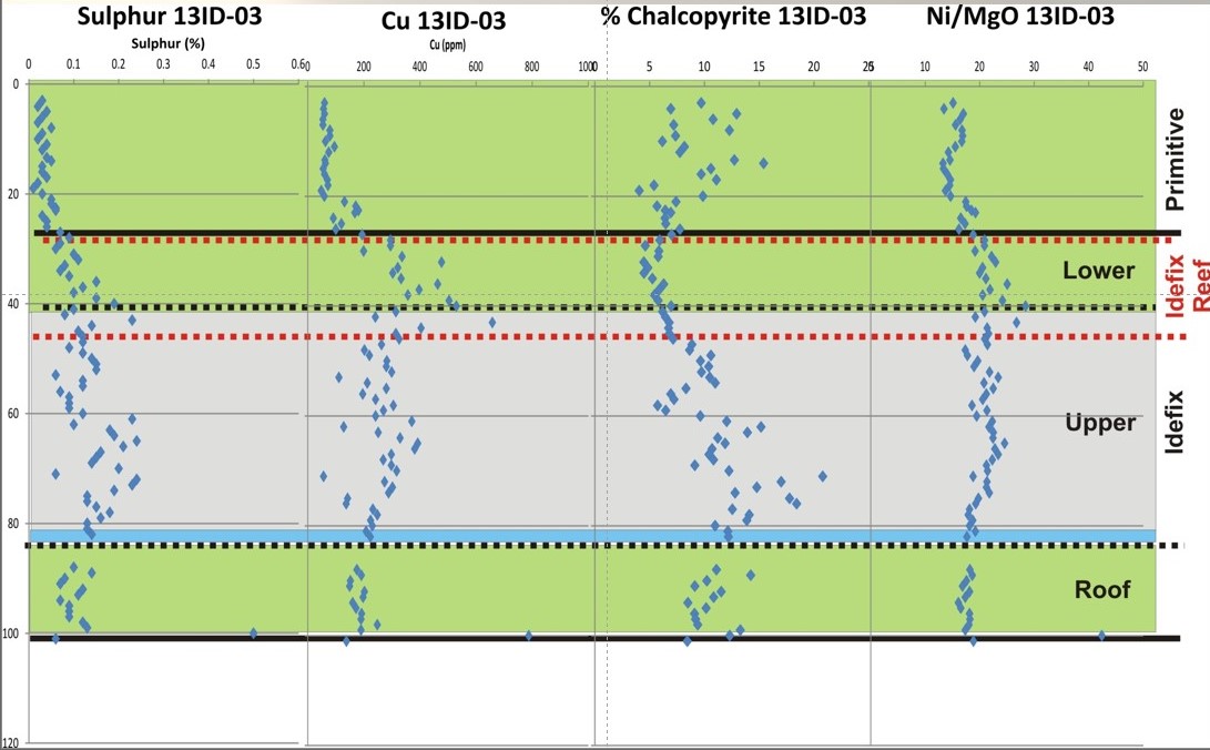
The high-grade mineralization (up to 16 g/t PGE+Au) that is observed on surface within the reef zone was not seen in drill core. It was noted that the high-grade surface mineralization is associated with hairline structures that seemed to have formed prior to the crystal mush solidifying. These fissures would be perpendicular to layering (hence parallel to drilling) and the focal point of fluids being filtered-pressed up through the sequence. These co-magmatic fissures are also observed in the Roof contact zone. As these fissures would be parallel to drilling, they could easily be missed in drilling.
Disseminated Mineralization.
The entire thickness of the Idefix Gabbro that sits above the reef contains approximately 0.1 g/t PGE+Au and is very homogenously distributed. This disseminated mineralization, when combined with the reef, adds up to a thickness of 50-60 meters averaging up to 0.25 g/t PGE+Au.
The mineralization is also associated with very low sulphide content at around 0.2% sulphur or 0.6% sulphide (pyrrhotite, chalcopyrite and pentlandite). This could be important as analysis at Idefix has shown that there is generally a linear relationship between sulphide content and PGE grades such that a 10x increase in sulphide content would generally bring about a 5-10x increase in PGE grade.
This is substantiated at La Colline where sulphide content averages 3% with PGE grades around 1.5 g/t PGE+Au.
Hybrid reef-contact type.
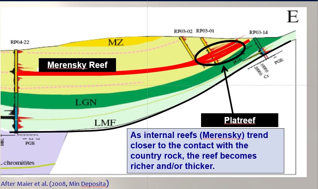
Approximately 900 m south of Idefix is the La Colline showing, where channel samples yielded average grades of 1.4 g/t PGE, 0.28% Cu and 0.13% Ni over 31.34 m. In total, 41 of 92 channel and grab samples at La Colline assayed greater than 1 g/t PGE+Au. The geochemical signature of La Colline is very different from that of the “Reef” and suggests that the mineralization here is either proximal to massive sulphides or a hybrid of the reef type model where the mineralization is upgraded where the reef comes into contact with the country rock. This would be analogous to the Platreef in South Africa, which is largely assumed to be the same stratigraphic level as the Merensky reef but where it becomes in contact with the country rock.
Sulphide Globules
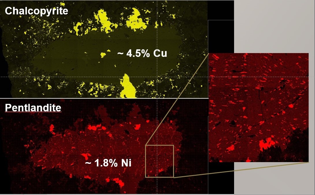
Globules of sulphide several centimetres in diameter are seen in drill core and on surface within the chill margin of the gabbro near the contact with the country rock. The globules consist dominantly of pyrrhotite with chalcopyrite rims suggesting that they originated from a pre-existing pool of sulphide liquid that existed prior to the pulse of magma that formed the Idefix unit. The globules contain up to up to 53 g/t Pd and typically contain 2-4% Cu and 1-3% Ni (pXRF).
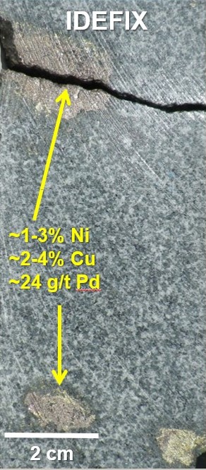
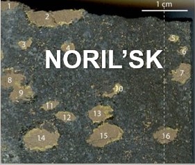
Sulphide globules are known to be very fragile and tend not to travel far from their source and remain intact. Similar globules are seen within a few tens of meters from the massive sulphides at Noril’sk. At Idefix, the intact globules are only seen within the chill margin, were rapid colling of the magma preserved them as they were. Closer to the centre of the sill, instability in the magma caused the globules to disaggregate and ultimately form small patches of net-textured sulphides.
